
EMPOWERING YOUTH THROUGH MAPS
|
Boomerang integrates open source geospatial technologies and STEM-focused curriculum into existing after-school and summer programs that support students of all ages. Boomerang's dynamic, hands-on workshops in data collection, GPS, and GIS provide students with the tools to apply technology to real-world problems. After-school workshops, classroom sessions, weekend programs, and summer programs are intended for students ages 13-18, and are customized to fit your educational and programming needs. Contact us & let's get mapping!
|
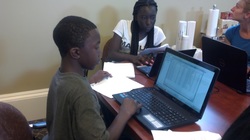
BoomGeo trains students in Parks & People's BRANCHES program
|
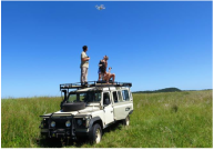
Aerial Mapping GIS & Web Maps MapGirlz! Data Collection
|
|

|

|
Learning extends beyond the classroom! We combine project-based learning with geospatial technology to encourage students to rediscover their communities and the environment in the field. Boomerang uses software like QGIS to give students the freedom to download at any time and give back to a growing tech community.