Save Sibaya, South Africa

Boomerang and Winterdodger Expeditions have teamed up to catalog and conserve the flora and fauna in the Lake Sibaya region. Lake Sibaya, South Africa's largest freshwater lake, is threatened by development, excessive poaching, and reduction of water levels due to regional consumption.
The goal of the Save Sibaya conservation effort is to slow the draining of Lake Sibaya and protect the area from further degradation. We will be building a comprehensive database of remaining species, creating a Sibaya Visitor Guide, and launching a tourist and community awareness campaign to garner interest in the area. Save Sibaya's social initiatives include working with the Ezinqeni community to renovate and upgrade the existing community center to host a mobile medical clinic, and for future use as an after-school center and kindergarten. Our hope is that one day soon, sustainable tourism will uplift the community, conserve this precious natural resource, and allow the remaining wildlife to flourish.
The goal of the Save Sibaya conservation effort is to slow the draining of Lake Sibaya and protect the area from further degradation. We will be building a comprehensive database of remaining species, creating a Sibaya Visitor Guide, and launching a tourist and community awareness campaign to garner interest in the area. Save Sibaya's social initiatives include working with the Ezinqeni community to renovate and upgrade the existing community center to host a mobile medical clinic, and for future use as an after-school center and kindergarten. Our hope is that one day soon, sustainable tourism will uplift the community, conserve this precious natural resource, and allow the remaining wildlife to flourish.
Conservation Project, Dqae Qare San Lodge, Botswana
|
This is a conservation project at Dqae Qare San Reserve, with the goal to create a sustainable project that will conserve not only the wildlife, but also the culture of the Naro San people.
In 2016 we began working with the San to develop a baseline wildlife census and track the predators in the area. Our team conducted transect surveys, night drives, and field tracking to kick off a year of similar efforts. We will be building a base camp and continuing the census throughout the coming year. In 2013, our team spent a week collecting data on the reserve. We drove each dirt road, mapped the fence line, and recorded all of the potential campsites, existing water resources, and points of interest. After data collection we created a campground resource map and a wall-size satellite map of the entire property (shown right). Learn more about Dqae Qare! |
|
Mapping the Klipspringer, Liwonde National Park, Malawi
Leakin Park Invasive Species Mapping
|
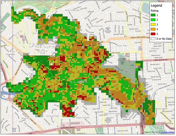
As part of a Hack the Parks grant, Boomerang spent the summer of 2013 collecting data on invasive species in Leakin Park in Baltimore, MD. Our team walked more than 400 acres assessing the impact invasive vines have had on each quarter acre of the park.
The result is an automatically-generated color-coded map of the entire park showing where the highest concentrations of ivy are located. This map will allow local organizations like Friends of Leakin Park and citizens to better focus removal efforts and track their progress. The Adopt-An-Acre Program has followed the mapping efforts and volunteers have been out in the park helping to save trees from invasive vines. |
Want to get involved? Click here to contact Friends of Gwenns Falls/Leakin Park!
Federal Hill Main Street Study
Mapping the Mascarene Plateau
After spending time in Mauritius, Boomerang saw the opportunity to better understand the regional coral reef system. This presentation is an idea for mapping the system. It is not a current project, but it could be soon!


